

Kingman Reef KQ
A largely submerged coral atoll in the North Pacific, nearly all of it underwater at high tide, once a Pan American Airways flying boat stopover and now one of the most pristine coral reef ecosystems on Earth.
About Kingman Reef
Kingman Reef is unlike any other U.S. territory. It is not really an island at all, it is a submerged coral atoll in the North Pacific, roughly triangular in shape and about 40 square miles in total area, but with almost none of that above water. At high tide, only a thin crescent of coral rubble and a handful of small reef flats break the surface. The total dry land area is smaller than a city block.
What Kingman lacks in land it more than makes up for underwater. Its reef system is considered one of the most pristine coral ecosystems on Earth. Because no one has ever lived here and commercial fishing has long been prohibited, the reef supports an extraordinary abundance of sharks, fish, and coral that scientists use as a baseline for what Pacific reefs looked like before human impact.
Its brief above-water history includes a stint as a Pan American Airways flying boat stopover in the late 1930s and a World War II naval waypoint. Today it is a federally protected wildlife refuge and a closed marine reserve within the Pacific Remote Islands Marine National Monument.

Aerial view of Kingman Reef, nearly all underwater

The lagoon interior where Pan Am flying boats once landed
Kingman Reef vs. a U.S. State
| Feature | Kingman Reef | U.S. State |
|---|---|---|
| Permanent Population | None | Yes |
| Local Government | None | State government |
| Congressional Representation | None | Senators + Representatives |
| Voting in Federal Elections | No residents | Yes |
| U.S. Constitution Applies | Partially (by statute) | Fully |
| Administered By | Fish & Wildlife Service | Elected officials |
| Incorporated Territory | No | Yes (as a state) |
| Public Access | Closed, no entry | Generally open |
Geography at a Glance
- Location
- North Pacific Ocean
- Coordinates
- 6°23′N 162°25′W
- Land Area
- ~0.01 sq mi (0.03 km²) at high tide
- Reef Area
- ~40 sq mi (103 km²) total atoll
- Highest Point
- ~3 ft (1 m) above sea level
- Nearest Land
- Palmyra Atoll (~35 mi SE)
- Distance to HI
- ~930 miles S of Honolulu
- Time Zone
- UTC−11:00
- Climate
- Equatorial, hot, wet, trade winds
- Administration
- U.S. Fish & Wildlife Service
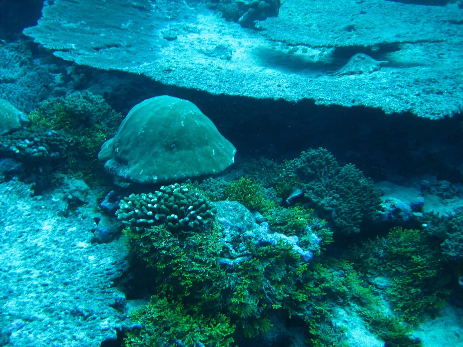
Kingman Reef's coral ecosystem, considered among the most pristine in the Pacific
Wildlife of Kingman Reef
Kingman Reef's near-total submersion means there is almost no terrestrial habitat, but the underwater world more than compensates. The reef system here is widely regarded by marine scientists as a reference ecosystem for what undisturbed Pacific coral reefs look like.
Kingman Reef's waters are extraordinary for shark abundance. Grey reef sharks, whitetip reef sharks, and silvertip sharks patrol the outer reef slopes in densities rarely seen anywhere else on Earth, a sign of a truly intact predator community.
Kingman hosts one of the most diverse and healthy coral reef ecosystems in the entire Pacific. Its isolation from human activity has kept coral cover, species diversity, and reef structure in near-pristine condition.
The lagoon and outer reef support hundreds of fish and invertebrate species in remarkable abundance. Reef fish biomass at Kingman is among the highest recorded anywhere in the Pacific Remote Islands region.
A small number of seabirds including frigatebirds and boobies nest on the few above-water rubble areas of the reef. The lack of dry land limits terrestrial wildlife, but the surrounding ocean more than compensates.
Kingman Reef Through Time
- ✦1798
First Recorded Sighting
The American sea captain Edmund Fanning, aboard the Betsey, recorded the reef in 1798 while sailing between Hawaii and the South Pacific.
Kingman is a triangular reef about 9 by 5 miles enclosing a deep lagoon, with only a strip or two of storm-piled coral rubble that barely breaks the surface, so it has always been a shipping hazard rather than a place anyone could use.
- ✦1853
Named for Captain Kingman
Captain W. E. Kingman of the ship Shooting Star surveyed and charted the reef in 1853, and it took his name on the charts.
Because the reef is nearly all underwater, no guano ever accumulated there and no one attempted to mine it, unlike the dry islands of the region.
- ✦1858
U.S. Claim Under Guano Act
The United States claimed Kingman Reef in 1858 under the Guano Islands Act of 1856, though there was no guano to take; the claim was really about denying the reef to other powers.
For decades nothing was done with it, and the reef appeared on charts mainly as a danger to navigation.
- ✦1922
Formal U.S. Annexation
The United States formally annexed Kingman Reef in 1922 (it was placed under Navy jurisdiction in 1934), driven by its position roughly halfway between Hawaii and American Samoa on the developing air and cable routes.
The annexation drew a protest from Britain, which had claimed the reef in the 1800s, but Britain did not press the point.
- ✦1937–1938
Pan American Airways Flying Boat Station
In 1937 and 1938 Pan American Airways used Kingman's sheltered lagoon as an anchorage and refueling stop for its Sikorsky S-42 flying boats on a survey route between Honolulu and Pago Pago, American Samoa.
A converted schooner, the North Wind, was moored in the lagoon with fuel and a crew to service the aircraft. Pan Am flew the route only a few times before a fatal crash of the Samoan Clipper near Pago Pago in January 1938 ended the service and the Kingman station with it.
- ✦1941–1945
World War II Naval Presence
During World War II the Navy used Kingman Reef only as a navigational reference and occasional patrol point; the lack of dry land made any installation impossible.
The reef stayed under nominal Navy control for the rest of the century with essentially no activity on it.
- ✦2001
Transfer to Fish & Wildlife Service
In 2001 administrative responsibility for Kingman Reef passed from the Navy to the U.S. Fish and Wildlife Service, which made it a National Wildlife Refuge covering the reef and lagoon out to 12 nautical miles.
The refuge has no facilities and is essentially never visited; it is one of the least-disturbed reef systems on Earth.
- ✦2009
Marine National Monument
Kingman Reef was included in the Pacific Remote Islands Marine National Monument in 2009, and its protected waters, like those of nearby Palmyra Atoll, extend 50 nautical miles; the 2014 expansion to 200 nautical miles covered only Wake, Johnston, and Jarvis.
Scientists studying Kingman and Palmyra together have used the pair as a natural experiment, comparing a reef with no human history at all to one with a lasting military footprint.
Did You Know?
Interesting facts about one of America's most unusual territories.
Kingman Reef is almost entirely underwater. At high tide, only a thin crescent of rubble and a few coral heads poke above the surface. The total dry land area is roughly the size of a city block.
In 1937 and 1938, Pan American Airways flying boats landed on Kingman Reef's lagoon as part of the pioneering trans-Pacific air route. A supply ship anchored in the lagoon served as the only infrastructure.
Scientists consider Kingman Reef one of the best examples of a shark-dominated coral reef on the planet. The ratio of apex predators to prey fish here is the inverse of most human-impacted reefs, where large predators have been fished out.
A 2005 scientific expedition to Kingman Reef found coral reef health indicators far exceeding those at any inhabited Pacific island, including near-pristine water clarity and coral cover rarely seen elsewhere in the world.
Kingman Reef is closed to the public entirely. There is no dry land to land on at high tide, no anchorage, and the U.S. Fish and Wildlife Service does not issue public access permits.
For centuries Kingman Reef was one of the most feared navigational hazards in the Pacific. Its nearly invisible profile at sea level caused numerous shipwrecks before it was reliably charted in the mid-1800s.
Quick Facts and Common Questions
Short answers to the questions people most often ask about Kingman Reef: where it is, how the United States acquired it, and who looks after it today.
Kingman Reef is a mostly submerged coral reef in the North Pacific Ocean, about 930 miles south of Honolulu and about 35 miles northwest of Palmyra Atoll. Only a tiny strip of coral rubble stays above water at high tide, so no one lives there, and it has long been a hazard to ships.
The reef is named for Captain W. E. Kingman, who described it in 1853. The United States annexed Kingman Reef in 1922, and in 1934 the Navy was given jurisdiction over it.
Yes. In 1937 and 1938 Pan American Airways used the reef's lagoon as a stopover for its flying boats on the route between Hawaii and American Samoa, before the airline moved its South Pacific route elsewhere.
Kingman Reef is an unincorporated, unorganized territory of the United States with no local government. The U.S. Fish and Wildlife Service, part of the Department of the Interior, manages it as Kingman Reef National Wildlife Refuge, established in 2001, and it is part of the marine national monument now called the Pacific Islands Heritage Marine National Monument. Visits require a special permit.
No. Kingman Reef has no residents, is not part of any state or congressional district, and has no delegate in Congress.