


About Utah
Utah takes its name from the Ute people, a Numic-speaking nation who inhabited the Great Basin and Colorado Plateau regions of the present-day American West. The name "Ute" may derive from a Southern Paiute word meaning "land of the sun" or from a word in the Ute language itself, though its precise origin is debated. Spanish explorers encountered the Ute in the 18th century and recorded various forms of the name. When Congress organized the Utah Territory in 1850, it named the territory after the indigenous people who lived there. The territory was dominated by members of the Church of Jesus Christ of Latter-day Saints, who had settled the Salt Lake Valley in 1847 after being driven from Missouri and Illinois. Utah became a state in 1896 after a decades-long conflict between the federal government and the LDS Church over the practice of polygamy.
Utah is a state of superlatives. It has the highest concentration of national parks of any state. The largest open-pit mine on Earth. The fastest-growing tech economy in the country. The highest birth rate and lowest median age in the nation. The Great Salt Lake, the largest saltwater lake in the Western Hemisphere, and one that is disappearing. The deepest powder snow in the world.
The state's character was shaped by the Church of Jesus Christ of Latter-day Saints, whose pioneer members settled the Salt Lake Valley in 1847 after fleeing persecution in the East. The LDS Church remains central to Utah's culture, politics, and demographics, roughly 60% of the state identifies as members, though that share has been declining as the state draws non-LDS tech workers and transplants from California and across the country.
The geographical divide between the urban Wasatch Front, home to 80% of the population in a narrow strip along the mountains, and the vast, sparsely populated red-rock desert that makes up most of the state's land area is one of the most striking contrasts in American geography. One part of Utah is a booming, young, tech-driven city. The other is some of the most ancient and untouched landscape on the continent.

Geography, Four Distinct Regions
Utah spans three major geological provinces, the Wasatch Mountains, the Colorado Plateau, and the Great Basin, producing one of the most geographically varied states in the country.
Nearly 80% of Utah's population lives on a narrow 100-mile corridor between the Wasatch Mountains and the Great Salt Lake, the Wasatch Front. Salt Lake City is the capital and cultural hub; Provo anchors the south with Brigham Young University; Ogden sits at the north.
The Wasatch Mountains rise dramatically directly behind Salt Lake City, providing world-class skiing at resorts like Alta, Snowbird, Park City, and Deer Valley, some of the deepest powder snow on earth, thanks to moisture from the Great Salt Lake. The Wasatch Front is also the heart of Utah's technology economy, a corridor that has earned the nickname 'Silicon Slopes.'
The corridor sits directly on the Wasatch Fault, one of the longest and most active normal faults in the country; geologists put the odds of a magnitude-6.75 or larger quake in the next 50 years at roughly one in four, striking under the state's population and its many unreinforced pioneer-era brick buildings. The benches of flat land the cities are built on are old shorelines of Lake Bonneville, the Ice Age lake that once covered a fifth of Utah before draining catastrophically about 18,000 years ago through a pass in southern Idaho.
Winter temperature inversions trap cold, polluted air against the mountains, and Salt Lake City periodically records some of the worst wintertime air quality in the country. The Great Salt Lake at the corridor's western edge fell to a record low in 2022, exposing lakebed laced with arsenic that blows into the air the Front breathes, and the 2023 legislature passed emergency measures to send more water down the rivers that feed it.
Southern Utah is one of the most visually extraordinary landscapes on Earth. The Colorado Plateau, the same geological formation that created the Grand Canyon, covers most of southeastern Utah in layer upon layer of red and orange sandstone, carved by wind and water over millions of years into arches, canyons, spires, and mesas.
Zion National Park, Bryce Canyon, Arches, Canyonlands, and Capitol Reef, the 'Mighty Five', are all on the Colorado Plateau and together represent some of the most visited and photographed landscapes in the world. Moab, once a uranium-mining town, has become the outdoor adventure capital of the American West.
The plateau's rock is a stacked record of roughly 300 million years, from the Permian white sandstone of Zion's cliffs to the pink limestone hoodoos of Bryce. It is also uranium country: the Atomic Energy Commission's ore-buying program set off a boom around Moab in the early 1950s, and Charlie Steen's 1952 Mi Vida strike briefly made him one of the richest men in America.
Bears Ears National Monument, created by President Obama in 2016 at the request of a coalition of five tribes, was cut by about 85% by President Trump in 2017 and largely restored by President Biden in 2021, making it the national test case for how far a president can go in shrinking a monument. Lake Powell, the reservoir behind Glen Canyon Dam, fell in 2022 to within about 30 feet of the level at which the dam can no longer generate electricity.
Western Utah is part of the Great Basin, an enormous region where no rivers drain to the ocean, all water evaporates or sinks underground. The Bonneville Salt Flats, a remnant of ancient Lake Bonneville, stretch across northwestern Utah as a perfectly flat, blindingly white expanse of salt.
The salt flats are the world's premier location for land speed records and have hosted dozens of record-breaking runs. The Great Salt Lake, the largest saltwater lake in the Western Hemisphere, occupies the northeast corner of the basin and has been shrinking dramatically in recent decades due to water diversion and drought, one of the most significant environmental crises in the American West.
Racers and scientists have warned for decades that the Bonneville salt crust is thinning, from perhaps six feet deep in the 1960s to under a foot in places, as brine is drawn off by a neighboring potash operation, and a 'salt laying' project now pumps some back each year. Land-speed records set on the flats include the first runs past 300, 400, 500, and 600 miles per hour.
The Great Salt Lake has no outlet, so it concentrates minerals to two to eight times the salinity of the ocean, supporting brine shrimp whose eggs are harvested and sold worldwide as fish and shrimp feed, along with huge summer flocks of migratory birds. Its surface area has roughly halved since the 1980s, and a 2023 Brigham Young University report warned the lake could largely disappear within a few years without major cuts in upstream water use, releasing a toxic dust plume over more than two million people.
The Uinta Mountains in northeastern Utah are the only major mountain range in the lower 48 states that runs east to west rather than north to south. Kings Peak, at 13,534 feet, is Utah's highest point.
The region is also one of the world's premier dinosaur fossil sites, Dinosaur National Monument on the Utah-Colorado border contains thousands of fossil bones embedded in a sandstone cliff face, one of the most spectacular paleontological displays anywhere. The Vernal area has yielded some of the most significant dinosaur finds in history, and the Utah Field House of Natural History is a premier destination for fossil enthusiasts.
The Uintas rose with the rest of the Rockies about 65 million years ago but along an unusual east-west axis, and glaciers later carved their high country into a plateau of more than a thousand lakes, most of it now protected as Utah's largest wilderness area. The Uinta Basin south of the range holds thick oil-shale and tar-sand deposits and a growing conventional oil field, and it suffers some of the worst winter ozone pollution in the country from drilling emissions trapped under temperature inversions.
The fossil wall at Dinosaur National Monument was found in 1909 by paleontologist Earl Douglass working for the Carnegie Museum, and about 350 tons of bones were shipped east before the site was protected; a building was later raised over the cliff so visitors can see roughly 1,500 bones still in the rock. Utah has produced more than 30 named dinosaur species, and in 2018 it adopted a state dinosaur, the Utahraptor, a large relative of Velociraptor first described from a Moab-area quarry.

Economy
Utah has one of the most diversified and fastest-growing economies in the nation, anchored by a booming tech sector, world-class tourism, major defense contracts, and significant mining and agriculture.
The Wasatch Front has emerged as one of the premier technology ecosystems in the country, earning the nickname 'Silicon Slopes.' Major tech companies including Adobe, eBay, Qualtrics, Domo, and dozens of others have significant Utah presences. The state consistently ranks first or second nationally in tech job growth, startup formation, and venture capital per capita.
Brigham Young University in Provo, the University of Utah, and Utah State produce large numbers of tech-literate graduates. The region's relatively low cost of living compared to the Bay Area, combined with outdoor recreation access and a highly educated workforce, has made it a magnet for tech talent and companies relocating from California.
The name 'Silicon Slopes' was popularized around 2013 by founders of Omniture, a Provo web-analytics company Adobe bought in 2009 for about 1.8 billion dollars, one of a string of large exits that seeded local investors and repeat founders. Qualtrics, also of Provo, was acquired by SAP in 2019 for 8 billion dollars, then spun back out in a 2021 IPO, among the largest ever for a Utah company.
Utah's workforce advantages are unusual: it has the youngest median age of any state, the highest birth rate, and a large pool of returned LDS missionaries who speak second languages and have overseas experience, which draws sales and customer-support operations. The boom has pushed housing costs up faster than in almost any state, and the 'Point of the Mountain' area between Salt Lake and Utah counties is being redeveloped from the old state prison site into a planned tech district.
Utah is home to five national parks, Zion, Bryce Canyon, Arches, Canyonlands, and Capitol Reef, collectively marketed as 'The Mighty Five.' Together they draw over 15 million visitors per year and generate billions in economic impact for the state and local communities. Zion alone hosts over 5 million visitors annually, making it one of the most visited national parks in the country.
Park City, site of the Sundance Film Festival and world-class ski resorts, is a major winter tourism destination. The tourism and outdoor recreation economy is one of Utah's largest and fastest-growing sectors.
Zion's popularity has outrun its roads: private cars have been barred from Zion Canyon for most of the year since 2000 in favor of a shuttle, and Arches began requiring timed-entry reservations in 2022. All five parks lie in rural southern Utah, and gateway towns such as Springdale, Moab, and Torrey struggle with housing shortages and limited water as visitation climbs.
Winter tourism centers on the Wasatch, where Park City Mountain and Deer Valley host World Cup ski racing; Salt Lake City staged the 2002 Winter Olympics and is set to host the Games again in 2034. The Sundance Film Festival, whose roots go back to a 1978 Utah film festival later run by Robert Redford's Sundance Institute, was held in Park City from 1981 through 2026 and is the largest independent-film festival in the United States; in 2025 it announced a move to Boulder, Colorado, beginning in 2027.
Hill Air Force Base near Ogden is the largest employer in the state, with over 22,000 military and civilian workers. Hill AFB is the primary depot for the F-35 fighter jet program, managing maintenance and logistics for the most advanced fighter aircraft in the world.
Northrop Grumman's propulsion facility in Promontory, Utah, formerly ATK, produces solid rocket boosters for NASA's Space Launch System and has manufactured rocket motors for nearly every major American space program since the 1950s. Dugway Proving Ground in the western desert is the Army's primary chemical and biological weapons testing facility.
Hill Air Force Base also hosts several operational F-35 fighter squadrons, and the Utah Test and Training Range to its west is the largest contiguous block of overland special-use airspace in the country, used for missile and munitions testing. The Ogden Air Logistics Complex at Hill overhauls landing gear and other components for much of the Air Force fleet.
Northrop Grumman's Promontory plant is the prime contractor for the Sentinel program, the roughly 140-billion-dollar replacement for the Minuteman III intercontinental missile, with much of the work centered in northern Utah. Dugway Proving Ground, about the size of Rhode Island, was the site of a 1968 open-air nerve-agent test that drifted off range and killed thousands of sheep in neighboring Skull Valley.
The Bingham Canyon Mine southwest of Salt Lake City is the largest open-pit copper mine in the world, a pit so large it is visible from space and has been designated a National Historic Landmark. Utah is a major producer of coal, though production has declined significantly as natural gas and renewables have displaced it.
The state also has substantial oil and natural gas production, particularly in the Uinta Basin. Potash, phosphate, and other minerals round out a diverse extractive sector that has shaped Utah's landscape and economy for over a century.
Bingham Canyon, worked since 1906 by what is now Rio Tinto's Kennecott operation, has produced more copper than any mine in history, along with gold, silver, and molybdenum. A massive landslide in April 2013 dropped about 165 million tons of rock into the pit, one of the largest non-volcanic slides in North American history, with no injuries because monitoring had forced an evacuation, and the smelter's stack is one of the tallest freestanding structures in the country.
Utah coal comes mostly from the Book Cliffs and Wasatch Plateau in the center of the state, where the 2007 Crandall Canyon mine collapse killed six miners and three rescuers; output has since fallen by more than half as utilities switched to gas and the state's big coal plants moved toward closure. The Uinta Basin produces a waxy, low-sulfur crude that trucks, and, if a long-disputed railway is built, trains would carry to Gulf Coast refineries.
Agriculture in Utah is constrained by the arid climate, less than 13 inches of rain per year statewide on average, but the state has developed a productive farming economy through irrigation. Utah ranks in the top five nationally in turkey production and is a significant producer of beef cattle, dairy products, hay, and onions. The Wasatch Front's fertile valley floor supports market gardening.
The famous Utah-grown sweet onions and Honeycrisp apples from the mountain valleys are known across the region. Food processing, including flour milling, dairy, and meat packing, adds value to agricultural production.
About three-quarters of Utah's cropland grows hay and other feed for livestock, and agriculture uses the large majority of the state's developed water, a fact now at the center of the fight to save the Great Salt Lake. Utah is a top-five turkey state, long tied to the Moroni-based Norbest cooperative, one of the oldest turkey marketing brands in the country.
The LDS Church runs one of the largest private ranching and farming operations in the country through its for-profit arm, tied historically to the Church's welfare and food-storage programs. Utah alfalfa and other hay are increasingly baled and shipped overseas, so a share of the state's scarce water effectively leaves as exported feed.

How Utah's State Government Works
Utah operates under a constitution adopted at statehood in 1896. The legislature, the Utah State Legislature, consists of a 29-member Senate and a 75-member House of Representatives. Utah holds a general session of 45 days each year, beginning in January. Special sessions can be called by the governor.
Utah is one of the most reliably Republican states in the country. The GOP controls all statewide offices, holds supermajorities in both legislative chambers, and has voted Republican in every presidential election since 1964, with one exception: 2016, when independent candidate Evan McMullin won 21.5% of the vote, reflecting significant LDS discomfort with Donald Trump.
Despite its deep red partisan lean, Utah has a notable tradition of moderate, pragmatic governance. Governor Spencer Cox has been one of the most nationally prominent voices for reducing political polarization, co-founding the 'Disagree Better' initiative that urged Americans to engage in more civil political discourse.
Governor of Utah
Current Governor
Spencer Cox

- Party
- Republican
- In Office Since
- January 4, 2021
- Elected
- 2020, re-elected 2024
- Term Ends
- January 2029
- Born
- July 11, 1975, Fairview, Utah
- Education
- Utah State University (BS); Washington & Lee (JD)
- Prior Role
- Lt. Governor (2013–2021)
Spencer Cox is the 18th Governor of Utah. A rancher's son from rural Sanpete County, he is one of the most nationally recognized governors in the country, not for controversy, but for his sustained effort to model respectful political discourse. He and his 2020 opponent ran a joint ad calling for civility that went viral. His administration has focused on housing, water (particularly the Great Salt Lake), and Utah's extraordinary economic growth.
Other Current State Officials
Lieutenant Governor
Deidre Henderson
In office since January 2021. Former state senator from Spanish Fork. Focuses on election administration, government transparency, and child welfare issues.
Attorney General
Derek Brown
In office since January 2025. Former state Republican Party chairman and state legislator. Succeeded Sean Reyes, who did not seek re-election in 2024.
State Treasurer
Marlo Oaks
In office since January 2021. Former financial professional. Manages Utah's state investment fund and focuses on ESG-skeptical investment policy, part of a broader conservative pushback on environmental and social investing criteria.
The Utah State Legislature
Utah State Senate
- Seats: 29 members
- Terms: 4-year terms
The upper chamber. Senators serve 4-year staggered terms. Republicans hold a supermajority, giving them complete control over legislation and the ability to override vetoes without Democratic votes.
Utah House of Representatives
- Seats: 75 members
- Terms: 2-year terms
The lower chamber. All 75 seats are on the ballot every two years. The legislature meets for a short 45-day session each January. Republicans have held supermajority control for most of the 21st century.
Utah's U.S. Senators
Every state gets exactly two U.S. Senators, regardless of population. Utah's senators serve 6-year terms and represent the entire state.
U.S. Senator
Mike Lee
One of the Senate's most ideologically consistent conservatives, elected in the 2010 Tea Party wave. Lee is a constitutional lawyer and former law clerk to Supreme Court Justice Samuel Alito. He has been a consistent voice for limiting federal power, reducing government spending, and strict constitutional interpretation. After the 2020 election, text messages released in 2022 showed he privately explored challenges to the results, but on January 6, 2021 he voted to certify the electoral votes. He is a close ally of President Trump and has been mentioned as a potential Supreme Court nominee. A devout member of the Church of Jesus Christ of Latter-day Saints, he is deeply influential in Utah politics.
U.S. Senator
John Curtis
Former Mayor of Provo and U.S. House Representative, elected to the Senate in 2024 to succeed retiring Senator Mitt Romney. Curtis is considered one of the most moderate Republicans in Congress, known for his emphasis on climate change as a genuine conservative concern and his willingness to work across the aisle. He founded the Conservative Climate Caucus in the House, arguing that Republicans must engage on climate rather than cede the issue to Democrats. His election marked the end of Mitt Romney's Senate career, Romney had become one of the few Republicans willing to consistently criticize Donald Trump.
Utah Through the Years
From early settlement to the present day. Tap any era to read more.
The Colorado Plateau of southern Utah was home to the Ancestral Puebloans (formerly called Anasazi) for over a thousand years before their mysterious abandonment of the region around 1300 CE. They left behind cliff dwellings, pottery, and petroglyphs across the canyon country.
The Ute people, for whom the state is named, were the dominant force across much of Utah when Spanish explorers arrived in the 18th century, skilled horsemen and traders with connections stretching across the Great Basin and into the Rocky Mountains. The Southern Paiute and Navajo also held significant territory in southern Utah.
The first documented Europeans in Utah were the Dominguez-Escalante expedition of 1776, two Franciscan priests seeking a route from Santa Fe to California who turned back near Utah Lake; their maps guided later travelers. The Old Spanish Trail that followed became a route for trading Ute-captured Paiute children into servitude in New Mexico and California, a traffic that Brigham Young's territorial government both curbed and, through legal 'indenture,' partly continued.
The Utah Territory Congress created in 1850 covered land now in five states, and its Native nations were pushed onto reservations over the following four decades: the Uintah and Ouray Reservation for the Ute in the northeast, part of the Navajo Nation, the country's largest reservation, in the southeast, and small Paiute and Goshute lands. The Northwestern Shoshone were massacred at Bear River, just over the Idaho line, in 1863, the deadliest single attack on Native people in U.S. history.
On July 24, 1847, Brigham Young led the first company of Mormon pioneers, members of the Church of Jesus Christ of Latter-day Saints, into the Salt Lake Valley after a grueling 1,300-mile journey from Nauvoo, Illinois. Facing intense persecution and mob violence in Missouri and Illinois (where founder Joseph Smith had been murdered in 1844), the Saints sought a place beyond the reach of the United States. Young reportedly said 'This is the right place, drive on' upon viewing the valley.
The Saints built Salt Lake City in the wilderness with remarkable speed. Over the following two decades, more than 70,000 pioneers made the trek, many pulling handcarts across the plains.
Young's advance company reached the valley on July 24, 1847, though he was in the last wagon, ill with 'mountain fever,' and saw it a day after the first scouts; the 'this is the place' line was recorded years later by others. Within days the pioneers had dammed City Creek, plowed, planted, and laid out Salt Lake City on a grid of ten-acre blocks oriented to the new temple site.
The migration was financed in large part by the Perpetual Emigrating Fund, a revolving Church loan program that between 1849 and 1887 helped tens of thousands of converts, most from Britain and Scandinavia, reach Utah. The handcart companies of 1856 to 1860 were the cheapest option; the Willie and Martin companies left too late in 1856 and were caught by early snow in Wyoming, and more than 200 people died before rescue parties from Salt Lake reached them.
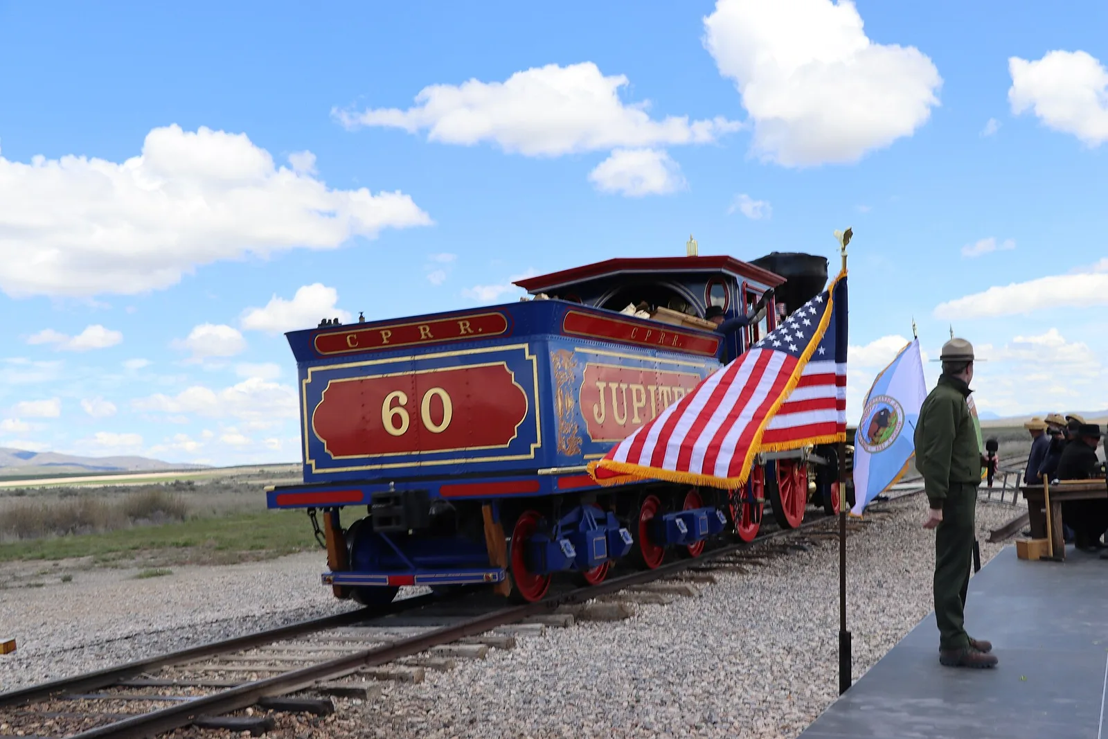
On May 10, 1869, the Central Pacific and Union Pacific railroads met at Promontory Summit in northern Utah, completing the first transcontinental railroad in the United States. A ceremonial golden spike was driven to mark the occasion, and telegraph lines carried the news instantly across the country, triggering celebrations from coast to coast.
The railroad transformed the American West, opening Utah and the entire region to commerce, settlement, and development on a scale previously impossible. Promontory Summit is now Golden Spike National Historical Park, where replica locomotives reenact the historic meeting.
The two railroads had graded past each other for more than 200 miles across Utah before Congress fixed the meeting point at Promontory Summit. Central Pacific's crews, roughly 90% Chinese immigrants, set a still-unbroken record of ten miles of track laid in a single day nearby in April 1869, and the Chinese workers were left out of the famous ceremonial photograph.
The line bypassed Salt Lake City by about 30 miles, so Brigham Young built the Utah Central Railroad to connect it. A shorter route straight across the Great Salt Lake, the Lucin Cutoff, replaced the Promontory grade in 1904, the original rails were pulled up for scrap in 1942, and the site became a national historic site in 1957.
Utah's path to statehood was the longest and most contentious of any territory in American history. Congress rejected Utah's statehood petitions in 1849, 1856, 1862, 1872, and 1887, primarily because of the LDS Church's practice of plural marriage (polygamy). The federal government passed anti-polygamy laws, confiscated Church property, and disenfranchised polygamists.
In 1890, LDS Church President Wilford Woodruff issued the Manifesto officially ending polygamy as a Church practice. After six years of demonstrating compliance, Utah was finally admitted to the Union on January 4, 1896 as the 45th state, with an explicit constitutional prohibition on polygamy.
The conflict turned violent in the 1857-58 'Utah War,' when President Buchanan sent about a third of the U.S. Army to install a non-Mormon governor; it ended in a negotiated settlement, but during the tension a Mormon militia and allied Paiutes massacred roughly 120 California-bound emigrants at Mountain Meadows in September 1857, a crime the Church did not fully acknowledge for 150 years.
The Edmunds-Tucker Act of 1887 dissolved the LDS Church as a legal corporation, seized its property, and abolished woman suffrage in the territory, where Utah women had voted since 1870, among the first in the nation. When Utah entered the Union in 1896, its constitution restored women's suffrage, and Martha Hughes Cannon, elected to the state senate that year in a field that included her own husband, became the first woman state senator in the United States.
Utah's five national parks, Zion (established 1919), Bryce Canyon (1928), Arches (1971), Canyonlands (1964), and Capitol Reef (1971), were recognized slowly over decades, but their collective fame has exploded in the social media era. The 'Mighty Five' marketing campaign, launched by Utah in 2013, transformed the state into one of the world's premier outdoor tourism destinations.
Instagram and social media turned Horseshoe Bend, The Wave, and Delicate Arch into globally iconic images. Annual visitation to Utah's national parks has more than doubled since 2010, creating both economic opportunity and significant overcrowding and environmental pressure on fragile desert ecosystems.
Monument politics have been fierce. President Clinton designated the 1.9-million-acre Grand Staircase-Escalante National Monument in 1996 without warning the state, announcing it from the Arizona rim of the Grand Canyon; Utah's leaders never forgave it, and the state has since pushed hard in Congress and the courts for the transfer of federal land, about 63% of Utah, to state control.
The 'Mighty Five' campaign worked almost too well: Arches began turning cars away on busy mornings and adopted timed-entry reservations in 2022, and the other parks have studied similar systems. The Utah Office of Tourism has since shifted spending toward promoting lesser-known state parks and shoulder-season travel to spread visitors out.
In the 21st century, Utah has emerged as one of the most economically dynamic states in the country. The 'Silicon Slopes' tech corridor between Salt Lake City and Provo has produced dozens of billion-dollar companies and attracted major tech employers, fueled by BYU and University of Utah talent, a highly educated and young workforce (Utah has the highest birth rate in the nation and the lowest median age), and a cost of living far below California.
Companies like Qualtrics, Domo, Pluralsight, and dozens of others were founded or relocated to Utah. The state consistently ranks at or near the top for economic growth, job creation, and entrepreneurship.
The turning point is usually dated to 2008 and 2009, when Adobe bought Provo's Omniture for about 1.8 billion dollars, minting a class of local angel investors and repeat founders. The pipeline was already there: BYU's business school runs one of the top-ranked entrepreneurship programs in the country, and the University of Utah was an early hub of computer graphics whose alumni founded or shaped Pixar, Adobe, Atari, and Silicon Graphics.
Utah has courted the industry with light regulation and infrastructure, including the 'Point of the Mountain' tech district being built on the site of the old state prison, and it hosts a large annual Silicon Slopes conference. The rapid growth has strained the Wasatch Front's housing, water, and air, and Utah has become one of the least affordable housing markets in the interior West.
Utah's Defining Moments in American History
These are the events that didn't just shape Utah, they changed the nation.
Between 1847 and 1868, more than 70,000 members of the Church of Jesus Christ of Latter-day Saints made the overland journey from the Midwest to the Salt Lake Valley, one of the largest organized religious migrations in history. The pioneers left behind their homes, farms, and communities after years of mob violence and persecution culminating in the murder of founder Joseph Smith. Brigham Young organized the migration with remarkable logistical precision.
Many pioneers, particularly those from Britain and Scandinavia who converted after LDS missionaries arrived in Europe, made the journey pushing handcarts, the poorest pulling all their possessions by hand across 1,300 miles of plains, desert, and mountains. The Mormon Pioneer Trail is one of the most significant migration routes in American history.
Young chose the Salt Lake Valley partly because it was then Mexican territory, outside the United States that had failed to protect the Saints; the U.S. acquired it months later in the 1848 Treaty of Guadalupe Hidalgo. His first act on arriving was to declare that land and water would not be bought and sold but allotted by the Church according to need, a communitarian system that produced Utah's pattern of tight farm villages and cooperative irrigation.
Between 1847 and 1890 the Church directed the founding of roughly 500 settlements across Utah and into Idaho, Nevada, Arizona, and Mexico, sending families on 'missions' to colonize particular valleys. The trek is re-enacted today by LDS youth groups pulling handcarts, and July 24, 'Pioneer Day,' is a Utah state holiday celebrated in the state more than the Fourth of July.
The completion of the first transcontinental railroad at Promontory Summit, Utah on May 10, 1869 was one of the defining technological and economic events in American history. The ceremony drove a ceremonial golden spike to join the Central Pacific (building east from Sacramento) and the Union Pacific (building west from Omaha), a feat accomplished in just six years using mostly Chinese and Irish immigrant labor under brutal conditions.
The railroad cut the journey from New York to San Francisco from six months to six days and made the settlement and economic development of the entire American West possible on a scale unimaginable before. Within a generation, the transcontinental railroad had fundamentally transformed the country.
Congress had chartered and heavily subsidized the two companies in the 1862 and 1864 Pacific Railway Acts, granting the whole system about 175 million acres of public land and lending millions in bonds per mile, an arrangement that produced both the railroad and the Credit Mobilier scandal, one of the worst corruption cases of the 19th century, exposed in 1872. Thousands of workers died building it, most of them Chinese, from avalanches, blasting, and disease.
The line sped white settlement and the destruction of the bison herds, gutting the Plains tribes' economy, and it wiped out the Pony Express and the overland stage almost overnight. It also bound California to the Union commercially at a time when its loyalty had been uncertain, and it set the template for the federal land grants that built most of the West's railroads over the next 20 years.
No state has a higher concentration of extraordinary natural landscapes per capita than Utah. Zion's towering sandstone canyon, Bryce Canyon's otherworldly hoodoo formations, Arches' 2,000+ natural stone arches (including the iconic Delicate Arch), Canyonlands' river-carved labyrinth, and Capitol Reef's hidden waterpocket fold represent some of the most dramatic geology on earth.
The Colorado Plateau that underlies all five parks was formed by the same forces that created the Grand Canyon, uplift, erosion, and the patient work of the Colorado River system over millions of years. Together the Mighty Five receive over 15 million visitors annually and are among the most photographed places in the world.
The parks protect only a slice of the plateau's public land; around them lie Grand Staircase-Escalante and Bears Ears national monuments, Glen Canyon and Lake Powell, state parks such as Dead Horse Point and Goblin Valley, and millions of acres of Bureau of Land Management canyon country open to hiking, climbing, and off-road travel. The region's dark skies have made it a center of astro-tourism, with more certified International Dark Sky Places than anywhere else on Earth.
The fragility that draws visitors also makes them a threat: cryptobiotic soil crust that takes decades to form is crushed by a single footstep, and Delicate Arch, Mesa Arch, and The Wave now draw lines and lotteries. Wallace Stegner, who grew up partly in Utah, called the plateau's canyons 'the geography of hope,' and the question of how many people that geography can absorb has become one of the defining land-use debates of the interior West.
Notable Utahns
Brigham Young
Second president of the LDS Church who led thousands of pioneers to the Salt Lake Valley
Philo Farnsworth
Inventor of the electronic television system, born in Beaver
Karl Malone
NBA legend known as The Mailman, spent his career with the Utah Jazz
Donny Osmond
Pop star, entertainer, and longtime Las Vegas headliner, born in Ogden
Wallace Stegner
Pulitzer Prize-winning author and conservationist called the dean of western writers, associated with Utah
Roseanne Barr
Comedian and actress whose self-titled sitcom was one of the most-watched shows of the 1980s and 90s, born in Salt Lake City
State Symbols & Quick Facts
| Nickname | "The Beehive State" |
| Capital | Salt Lake City |
| Largest City | Salt Lake City |
| Statehood | January 4, 1896 (45th state) |
| Population | ~3.4 million (2025 est.) |
| Area | 84,899 sq mi, 13th largest state |
| Motto | "Industry" |
| State Bird | California Gull |
| State Flower | Sego Lily |
| State Tree | Quaking Aspen |
| State Animal | Rocky Mountain Elk |
| State Fish | Bonneville Cutthroat Trout |
| State Insect | Honeybee |
| State Song | "Utah, This Is the Place" |
| Time Zone | Mountain Time (UTC−7 / UTC−6) |
| Borders | Idaho & Wyoming (N), Colorado (E), Arizona (S), Nevada (W) |
Did You Know?
The Bingham Canyon copper mine southwest of Salt Lake City is the largest man-made excavation on Earth, a pit 2.75 miles wide and nearly a mile deep that has been designated a National Historic Landmark. It is clearly visible from space and has produced more copper than any mine in history.
Utah has the highest birth rate in the United States and the lowest median age of any state. The average Utah family has more children than the national average, driven in part by the LDS Church's emphasis on family. Utah also has the highest literacy rate in the nation.
The Great Salt Lake is the largest saltwater lake in the Western Hemisphere, but it is shrinking rapidly. Since the 1980s, the lake has lost over half its surface area and about 75% of its volume due to water diversions for agriculture and cities. Scientists warn that if current trends continue, it could disappear within decades, with catastrophic effects on the regional ecosystem and air quality.
Utah contains more natural arches than anywhere else on Earth. Arches National Park alone has over 2,000 documented natural sandstone arches, the highest concentration in the world. The iconic Delicate Arch, standing 52 feet tall, appears on Utah license plates and is one of the most recognized natural landmarks in North America.
Salt Lake City hosted the 2002 Winter Olympics, with Park City staging many of the ski events, and the Wasatch Range is home to some of the deepest powder snow in the world. Utah's ski resorts market themselves on 'The Greatest Snow on Earth', a phrase on the state's license plates, because moisture from the Great Salt Lake creates uniquely light, dry powder that is prized by skiers worldwide.
Quick Facts and Common Questions
Short answers to the questions people most often ask about Utah: its abbreviation, why its statehood took so long, its capital, and its place in Congress.
Utah's two-letter postal abbreviation is UT. The U.S. Census Bureau places it in the West region, in the Mountain division, and about 3.27 million people lived there in the 2020 census.
Utah became the 45th state on January 4, 1896. Members of the Church of Jesus Christ of Latter-day Saints, led by Brigham Young, arrived in the Salt Lake Valley on July 24, 1847, a date still celebrated as Pioneer Day, and Congress created the Utah Territory in 1850.
Congress repeatedly turned down statehood, largely because of the church's practice of polygamy, which federal laws outlawed in 1862 and later. After church president Wilford Woodruff issued the 1890 Manifesto ending official approval of new plural marriages, Utah adopted a constitution that permanently bans polygamy, and it was admitted in 1896. The land had come from Mexico in 1848 after the Mexican-American War.
Utah is named for the Ute people, whose homeland covered much of the region. The name is often said to mean "people of the mountains."
Salt Lake City has been the capital since 1856. Fillmore, in the center of the territory, was chosen as the first territorial capital in 1851, but only one legislative session met in its statehouse before the government moved back to Salt Lake City. The current State Capitol was completed in 1916.
Utah borders Idaho and Wyoming to the north, Wyoming and Colorado to the east, Arizona to the south, and Nevada to the west. It touches New Mexico at the Four Corners, the only point where four states meet.
The first transcontinental railroad was completed on May 10, 1869, at Promontory Summit, Utah, when the Central Pacific and Union Pacific lines met and a ceremonial golden spike was driven. The site is Golden Spike National Historical Park.
The Utah territorial legislature gave women the vote in February 1870, and Seraph Young became the first woman to vote under an equal suffrage law that month. Congress took away that right in 1887, but Utah's 1896 state constitution restored it.
Utah is known as "The Beehive State," and its motto is "Industry," both symbols of hard work. Its state bird is the California gull, its flower is the sego lily, and its tree is the quaking aspen.
Based on the 2020 census, Utah has 4 seats in the U.S. House of Representatives, the same as before, which gives it 6 votes in the Electoral College.
Zion National Park
Utah's First National Park, Where the Virgin River Has Cut a 2,000-Foot Sandstone Gorge Through the Edge of the Colorado Plateau
About Zion National Park
Zion National Park, established in 1919, was Utah's first national park and is now one of the most visited in the system, drawing around 4.5 to 5 million people a year to a canyon less than a mile wide in places. It protects 147,242 acres on the edge of the Colorado Plateau in southwestern Utah, near Springdale.
The centerpiece is Zion Canyon, where the North Fork of the Virgin River has cut a gorge up to 2,640 feet deep through the salmon-and-cream cliffs of Navajo Sandstone. The river still carries roughly a million tons of sediment a year out of the canyon, deepening it about one foot every thousand years.
Elevation ranges from about 3,700 feet at Coalpits Wash to 8,726 feet at Horse Ranch Mountain, spanning desert, riparian, woodland, and forest life zones. More than 1,000 plant species, 290 birds, and 79 mammals have been recorded, and hanging gardens of maidenhair fern and columbine grow where groundwater seeps from the cliffs.
Because the main canyon road is narrow and parking is scarce, the park has run a mandatory propane shuttle in Zion Canyon from spring through fall since 2000, and it has added timed-entry permits by lottery for Angels Landing and the through-hike of The Narrows to spread out use of its most crowded routes.
- Designation
- National Park
- Location
- Springdale, Utah, southwestern Utah
- Established
- 1919
- Annual Visitors
- ~4.5 million
Key Features
Zion's cliffs are carved from Navajo Sandstone, laid down about 180 to 190 million years ago in the Early Jurassic when a sand sea the size of the modern Sahara covered the western United States. The formation is up to about 2,200 feet thick here, among the thickest exposures anywhere.
The long, sweeping lines in the rock, called cross-bedding, are the preserved faces of ancient dunes up to a thousand feet tall, frozen at the angle the wind piled them. Lime-rich groundwater later cemented the sand grains together, and where that cement is strongest the rock stands in vertical cliffs.
The color comes from iron: the lower cliffs are stained deep red by iron oxide leached down from above, while the upper rock keeps its original pale cream. Black streaks on the walls are desert varnish, a thin coating of manganese and iron oxides deposited by microbes over centuries.
The same sandstone forms the slickrock of Arches, Canyonlands, and the Grand Staircase and stores much of the region's groundwater, feeding the springs and hanging gardens that make Zion Canyon far greener than the desert around it.
The Narrows is the gorge of the North Fork of the Virgin River above Zion Canyon, where the walls close to as little as 20 to 30 feet apart and rise 1,000 feet or more. For long stretches there is no bank, and the river fills the canyon wall to wall, so the hike is a wade up the streambed itself.
The full route runs 16 miles one way from Chamberlain Ranch, on private land above the park, down to the Temple of Sinawava, and needs a permit; it is usually done in one long day or with a single backcountry campsite. Most visitors instead do the bottom-up day hike from the Temple of Sinawava, which needs no permit and can be turned around at any point.
Water temperature stays cold year-round, often in the 50s Fahrenheit, and outfitters in Springdale rent neoprene socks, canyoneering boots, and drysuits in cooler months; hypothermia is a real risk even in summer.
Flash flooding is the central hazard. A thunderstorm miles away in the upper watershed can send a wall of muddy water down the slot with almost no warning; the park issues a daily flash-flood potential rating and closes the hike when the risk is high, and deaths have occurred when hikers were caught in a rising river.
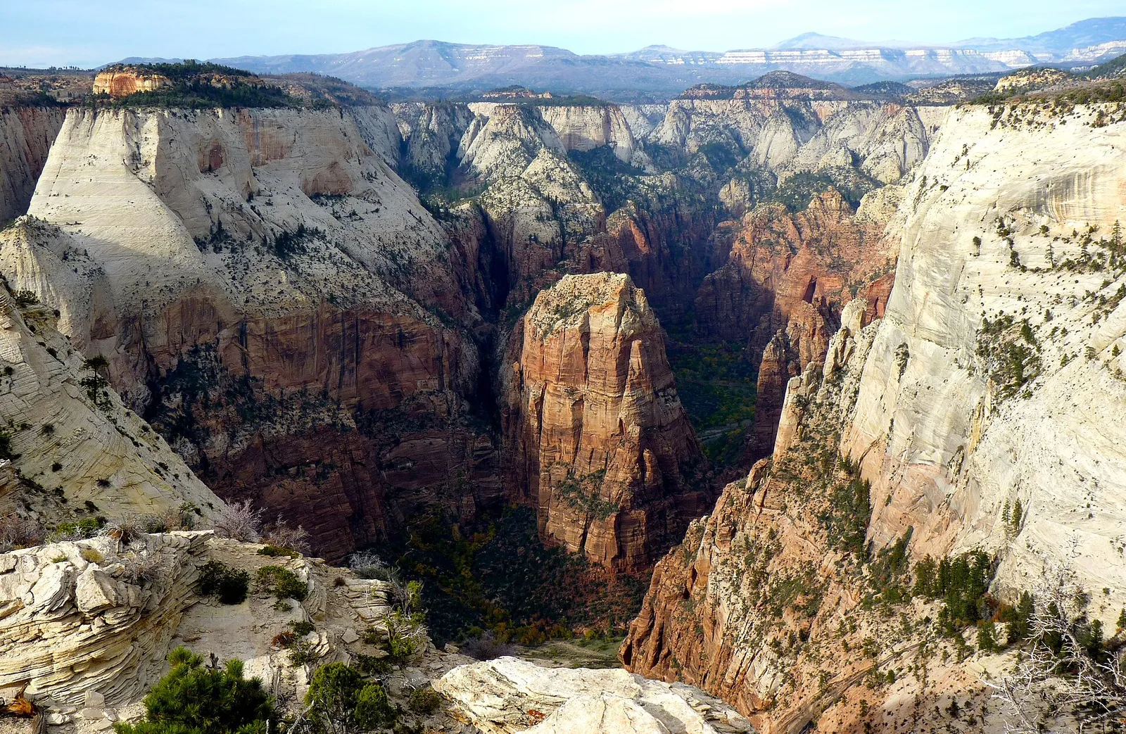
Angels Landing is a fin of rock that juts into Zion Canyon, ending in a summit 1,488 feet above the canyon floor. The West Rim Trail to it, blasted into the cliff in 1926, climbs through a hanging valley called Refrigerator Canyon and up Walter's Wiggles, 21 tight masonry switchbacks engineered under the park's first custodian, Walter Ruesch.
From Scout Lookout the last half mile follows the spine of the fin, with drop-offs of hundreds of feet on both sides, aided by heavy chains bolted into the rock. The round trip is about 5 miles with 1,500 feet of climb.
At least 15 people have died in falls from the route since 2000, and long lines on the single-file chain section became a hazard in themselves. In April 2022 the park began requiring a permit, issued by seasonal and day-before lotteries on Recreation.gov, to hike past Scout Lookout.
The name dates to 1916, when a visitor remarked that only an angel could land on the summit. The peak's isolation makes it prime habitat for peregrine falcons, which sometimes trigger spring closures of nearby climbing routes.
The Zion-Mount Carmel Highway, opened in 1930 after three years of construction, links Zion Canyon to the park's east side and the wider Utah parks circuit, climbing about 800 feet up the canyon wall in a series of switchbacks to reach the slickrock plateau.
Its centerpiece is the Zion-Mount Carmel Tunnel, 1.1 miles bored through the Navajo Sandstone, with galleries cut to the cliff face that once served as windows and viewpoints. At completion it was the longest highway tunnel in the United States.
The tunnel was built for 1920s cars and is too narrow for two-way traffic when a large vehicle is present. Since 1989, RVs, buses, and other oversized vehicles must pay a fee and pass one way at a time under ranger traffic control, and bicycles and pedestrians are banned from the tunnel entirely.
On the east side the highway runs through Checkerboard Mesa and other cross-bedded domes and past the trailhead for the short Canyon Overlook Trail; it stays open year-round, though it can close briefly for snow, ice, or rockfall.
Indigenous Heritage
Southern Paiute and ancestral Puebloan peoples
People have used the Zion area for at least 8,000 years. Ancestral Puebloan farmers, sometimes called the Virgin Anasazi, lived along the Virgin River from roughly 500 CE, growing corn, beans, and squash on the terraces and storing grain in stone granaries tucked into cliff alcoves, several of which survive in the park. They left the region around 1200 CE, most likely during a prolonged drought.
Southern Paiute bands, who call themselves Nuwuvi, moved through and lived in the area afterward, hunting, gathering pinyon nuts and agave, and farming small plots. Their name for the canyon was Mukuntuweap, which Major John Wesley Powell recorded in 1872; it was the canyon's official title as Mukuntuweap National Monument from 1909 until the 1918 renaming to Zion, the name Mormon settlers had given it.
Mormon pioneers settled the lower canyon and grazed and farmed it heavily from the 1860s, and the Paiute were pushed onto small reservations. Their descendants today include the Kaibab Band of Paiute Indians in Arizona, the Paiute Indian Tribe of Utah, and other Southern Paiute governments the National Park Service consults on cultural resources and place names.
The Southern Paiute have several federally recognized bands in Utah and Nevada with historical ties to the Zion region. The Kaibab Band of Paiute Indians and other Southern Paiute groups maintain cultural connections to the landscape. The park service consults with Southern Paiute groups on management decisions affecting cultural resources.
Things To Do
Angels Landing
Angels Landing is among the best-known hikes in the national park system: a 5.4-mile round trip with about 1,500 feet of climb, ending with a half-mile ridge scramble on a fin of rock with sheer drops on both sides.
The paved lower trail switchbacks up from the Grotto shuttle stop, passes through the shaded slot of Refrigerator Canyon, and climbs Walter's Wiggles, 21 short masonry switchbacks, to Scout Lookout. Many hikers stop there for the view and skip the chains.
The final section from Scout Lookout to the summit follows heavy chains bolted into the sandstone; it is single-file, exposed, and dangerous when wet, icy, windy, or crowded, and falls here have killed at least 15 people since 2000.
Since April 2022 a permit is required to go past Scout Lookout, awarded through seasonal and next-day lotteries on Recreation.gov. Rangers check permits at the base of the chains, and the system has cut the worst of the congestion.
The Narrows (Bottom-Up)
The bottom-up Narrows hike starts at the Temple of Sinawava, the last shuttle stop, follows the paved Riverside Walk for a mile, then steps into the Virgin River and continues upstream in the water. No permit is needed, and hikers turn around whenever they choose; Big Spring, about 5 miles up, is the limit for day hikers.
The route is a wade over slick, ankle-rolling cobbles against a current that can be knee- to waist-deep. A sturdy walking stick or trekking poles and closed-toe shoes with good grip are close to essential, and Springdale outfitters rent purpose-built boots, neoprene socks, and, in cold months, drysuits.
Highlights come quickly: the canyon narrows sharply past the 'Wall Street' section, and Mystery Falls, a ribbon of water sliding down the slickrock from a hanging canyon, appears around mile 1.
Flash flooding can raise the river several feet in minutes with no local rain. The park posts a daily flash-flood rating; when it is 'probable' the hike closes, and hikers are told to climb to high ground and wait, not try to outrun a flood, if the water turns brown or rises.
Emerald Pools Trails
The Emerald Pools trails climb to three tiers of pools fed by seasonal waterfalls spilling off the cliffs of Heaps Canyon, on the west side of Zion Canyon near Zion Lodge. The pools take their color from algae, not from unusual mineral content.
The Lower Pool trail, about 1.2 miles round trip, is paved and nearly level and passes behind a dripping alcove where the falls mist the path. The Middle Pool adds a short steep pitch, and the Upper Pool, about 3 miles round trip total, ends at a larger pool beneath a high headwall.
Flow is highly seasonal: the falls run hard in spring snowmelt and after storms and can slow to drips or stop by late summer. Rockfall has periodically closed sections, and a 2019 rockfall damaged part of the trail system.
The pools connect to the Kayenta Trail, which links to the Grotto shuttle stop and the Angels Landing trailhead, so many visitors combine them into a loop of a few miles.
Canyon Overlook Trail
The Canyon Overlook Trail starts just east of the Zion-Mount Carmel Tunnel and returns one of the best views in the park for about a mile of walking and 160 feet of climb. There is no shuttle to the trailhead; hikers drive the highway and use the small, often-full lots on either side of the tunnel.
The path traverses slickrock ledges and a boardwalk section above Pine Creek Canyon, with drop-offs and a few railings, ending on a promontory that looks down the lower Zion Canyon toward the West Temple and the Towers of the Virgin.
From the overlook, hikers can see the Great Arch of Zion, a huge blind arch open only on one face in the cliff below, and trace the switchbacks of the highway climbing the canyon wall.
The trail is short but not casual: it has uneven footing, exposure, and afternoon sun, and it is a popular sunrise and sunset spot, which crowds the tiny parking area.
Conservation and Challenges
Overcrowding and Shuttle System
Zion drew fewer than 1 million visitors a year into the 1970s; it now sees 4.5 to 5 million, most concentrated in the 6-mile main canyon between April and October. Traffic and parking in the canyon became unmanageable in the 1990s.
Since 2000 the Zion Canyon Scenic Drive has been closed to private cars during the busy season, served instead by a free shuttle that runs from the visitor center up the canyon and connects to a second line through Springdale. The propane-powered fleet carries several million riders a year.
The shuttle fixed congestion inside the canyon but not at the gates: the entrance station, the visitor center lot, and Springdale still back up on peak days, and the park has studied but not adopted a timed-entry reservation to enter the park itself.
To protect specific places, the park added chain-section permits for Angels Landing in 2022 and has long required permits for The Narrows through-hike, the Subway, and other canyoneering routes, capping daily numbers to limit trampling, human waste, and erosion.
Flash Flooding and Visitor Safety
Zion's slot canyons drain large areas of slickrock that shed rain almost instantly, so a storm cell miles from a hiker can send a flash flood down a canyon under blue sky overhead. The Virgin River and its tributaries can rise 10 feet or more in minutes.
The park issues a daily flash-flood potential rating, from 'not expected' to 'expected,' based on National Weather Service forecasts and closes The Narrows, the Subway, and technical canyons when the risk is high, but the ratings are probabilities, not guarantees.
The deadliest recent event was September 14, 2015, when seven canyoneers were killed by a flash flood in Keyhole Canyon; the same storm system killed 13 people in nearby Hildale that day. Other drownings and sweep-aways have occurred in The Narrows.
The park's guidance is blunt: check the forecast and the rating, do not enter a narrow canyon if storms are possible anywhere in the watershed, and if caught, climb to the highest ground available and wait it out rather than trying to move downstream.
Cottonwood Decline
Fremont cottonwoods line the Virgin River through Zion Canyon, shading the water, holding the banks, and providing the tallest nesting habitat in the park for birds like the southwestern willow flycatcher. Their survival depends on the river's natural flood cycle.
Cottonwood seeds stay viable for only a week or two and must land on bare, wet sediment left by a receding spring flood to sprout. Warmer winters, earlier and smaller snowmelt peaks, and drought have made those conditions rarer, so few new trees establish while the old ones age.
Non-native tamarisk (saltcedar) has spread along the same banks, competing with cottonwood seedlings, using scarce water, and raising fire risk in a corridor that historically rarely burned.
The park removes tamarisk in priority reaches, monitors cottonwood age structure and regeneration, and studies whether managed high flows or planting could sustain the gallery forest as the climate dries.
Angels Landing trail with chain-assisted scramble to the 5,790-foot summit
Fast Facts
Did You Know?
Angels Landing gets its name from a story that the peak was so high and sheer that only an angel could land there. The trail to the summit, completed in 1926, required engineers to carve 21 hairpin switchbacks called Walter's Wiggles into the rock face just to reach the base of the final ridgeline. The chain-assisted section that follows is only half a mile but involves scrambling along a ridge with thousand-foot dropoffs on both sides. The park implemented a permit lottery in 2022 after increasing traffic and several fatalities prompted the need to manage the trail more carefully.
The Narrows slot canyon is narrow enough that hikers must wade in the Virgin River for most of the route, often pushing against current in knee-to-waist-deep water while standing on slick, algae-covered cobblestones. The canyon walls rise hundreds of feet on both sides, and at the narrowest point only about 20 feet separates one wall from the other. The same geology that creates this dramatic scenery also makes the canyon deadly during flash floods: water from storms miles upstream can arrive as a wall of water with little warning, filling the canyon from wall to wall in minutes.
Zion National Park spans five distinct life zones from desert at the canyon bottom to coniferous forest on the high plateaus, creating remarkable ecological diversity in a compact area. The canyon floor supports lush riparian vegetation including cottonwood, willow, and box elder that would seem more at home in a much wetter climate. The contrast between the harsh desert conditions on the canyon rim and the lush green corridor along the Virgin River just hundreds of feet below is one of the defining visual experiences of Zion.
Plan Your Visit
Location
Springdale, Utah, southwestern Utah
Designation
National Park
Getting There
Zion is located in southwestern Utah, about 2.5 hours from Las Vegas, 4.5 hours from Salt Lake City, and 1.5 hours from St. George. The town of Springdale adjoins the south entrance and offers lodging, food, and gear rentals.
Entrance Fee
$35 per vehicle (7-day), or use an America the Beautiful pass. The park charges the fee at the entrance station.
Shuttle System
Private vehicles are not permitted on Zion Canyon Scenic Drive from April through October (and busy weekends beyond that). A free park shuttle runs from the Zion Canyon Visitor Center to all trailheads in the canyon. The shuttle is the primary mode of access during peak season.
Angels Landing Permit
A permit is required for the chains section of Angels Landing on Fridays, Saturdays, Sundays, and holidays from March to November. Apply via lottery on Recreation.gov. The seasonal lottery opens in January; day-before lotteries also run each morning.
The Narrows
Waterproof gear and walking sticks are strongly recommended for The Narrows. Rentals are available in Springdale. Check flash flood conditions on the park website before entering. The hike closes when flash flood risk is high.
Best Seasons
Spring (March-May) and fall (September-November) have the most comfortable temperatures. Summer is very hot in the canyon bottom and extremely crowded. Winter offers solitude and snow on the canyon walls but The Narrows and some trails may be icy.